

Can Tactical Lane Delineation Reclaim UK Urban Space?
The car-dominated, free-flow traffic orthodoxy that has governed British street design for the past fifty years has left us with wide carriageways, overly wide lanes, lane standards that prioritise speed and throughput over community cohesion, safety and environmental sustainability, and road layouts that discourage non-vehicle movement and penalise those who dare to cross.
Across the UK, urban planners, local authorities, and community activists are waking up to the fact that lane delineation can be used not just to separate traffic, but to actually transform how our streets work.
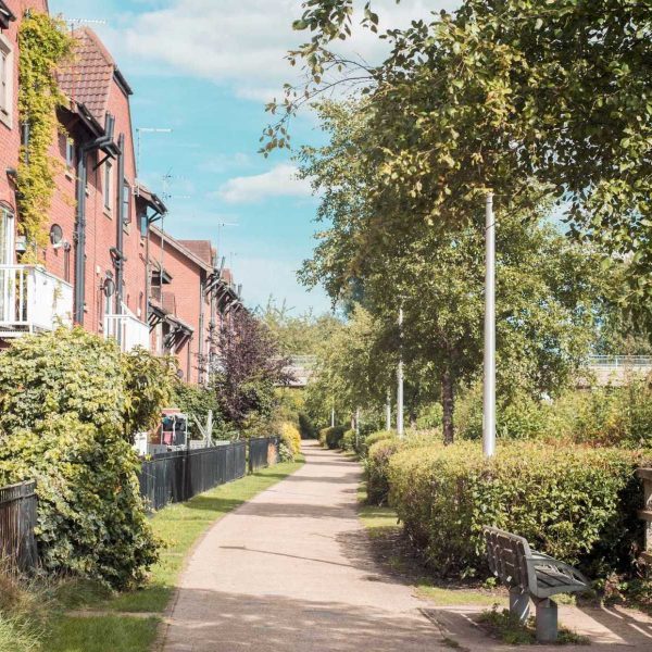
Lane delineation, in its most creative and effective applications, is about more than painted lines on the tarmac. It is a tactical intervention that can be used to slow cars, redistribute the balance of road space, improve pedestrian safety, and reclaim the streets for people. From the cobbled heritage streets of York and Bath to London and Manchester’s cycle superhighways, the tactical manipulation of lane width, lane configuration, and lane surface treatments is one of the most cost-effective and rapidly deployable tools in the traffic calming arsenal that local British municipalities now have at their disposal.
The Psychology and Physics of Lane Width
The relationship between lane width and vehicle speed is well documented, but not particularly well understood by the general public. Intuition and conventional wisdom holds that narrow lanes are worse—vehicles are more likely to be sideswiped or rear-ended, the cars are bunched up and stuck in traffic, creating pollution and frustration for all. Wide lanes, by contrast, are intuitively more safe, and better able to accommodate traffic flow. Transport engineering research and the experience of trial projects on streets around the UK paint a rather different picture, however.
Research by Transport for London from 2015 to 2019, for example, found that narrowing lane widths from 3.65m to 3.0m reduced average vehicle speeds by between 3 and 7 mph, depending on the street in question. More importantly, the narrower lanes did not result in an increase in the number of collisions; on some trial sites, there were marginal safety improvements. This effect is driven by driver psychology: as the visual field narrows, the driver instinctively slows down and pays more attention. The physical road environment gives the subconscious cues that it is safe to go faster, and the drivers will respond by driving faster.
Sarah Pemberton is a chartered transport planner with over two decades advising local councils in the Midlands. “We’ve spent generations building roads which feel safe to drivers at high speed,” she explains. “That’s the problem. When a street is safe at 40 mph, drivers will naturally drive at 40 mph, speed limit or not. Lane delineation is one way to redesign the physical environment, and visual language of a street so that 20 mph feels like the natural, comfortable speed.”
This is a shift away from enforcement-based speed management, and towards design-based speed management. Instead of relying solely on speed cameras, or traffic police, or posted signage, tactical lane delineation can, if done properly, create self-enforcing streets, where the right speed feels natural.
Lane Narrowing and Lane Reallocation
Lane narrowing is the most obvious and immediate application of lane delineation, and where the most compelling evidence is now available to support the technique. In Birmingham’s Jewellery Quarter, a lane narrowing project in 2018 reduced traffic lane widths along the main routes from 3.5m to 2.75m, with the space reallocated to wider pavements and cycle tracks. Pre-intervention 85th percentile speed in the 20 mph zone was 34 mph. Sixteen months after the change, that figure had reduced to 24 mph. Compliance rates improved from 23% to 67% after the change.
The financial impact on the local economy of such a project goes far beyond traffic management. Business associations in the Jewellery Quarter reported a 14% increase in footfall, and an 8% rise in retail spending, in the year after the lane narrowing project. Pavement widening allowed for outdoor seating, greater accessibility for wheelchair users and pushchairs, and the street character changed from that of a thoroughfare to a destination.
Lane reallocation is another application of lane delineation to use. Edinburgh’s Leith Walk regeneration included lane reallocation to create protected cycle lanes and widen pedestrian zones. Prior to the intervention, there were around 18,000 vehicle movements on Leith Walk daily, with average speeds of 28 mph. Post-intervention, vehicle movements reduced to around 14,000, a 22% decrease, with average speeds reducing to 21 mph. Crucially, journey time reliability for buses actually improved, as the impact of the reduction in traffic levels outweighed the speed reduction from the narrower lanes.
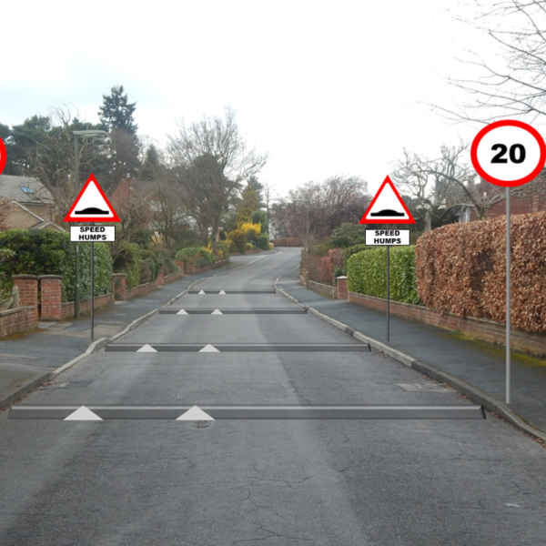
Chicanes and Pinch Points
Chicanes and pinch points are another lane delineation technique, but rather than a continuous speed reduction tool, they provide a punctuated, visual and physical intervention, forcing drivers to actually slow down and navigate their way around the obstacle. They do this through horizontal deflection: by physically requiring the vehicle to leave the straight path and change direction, the driver is required to slow down and pay attention.
Somerset’s market town of Frome has implemented a series of build-outs and chicanes along its main approach roads, using painted delineation, flexible bollards, and planted kerb extensions. Speed monitoring data collected over a two-year period has shown a sustained reduction in average speeds from 36 mph to 26 mph at the chicane locations, with downstream effects of several hundred metres beyond each intervention point.
Marcus Chen is a community campaigner who led the movement for traffic calming in Frome. “Residents had been complaining about speeding traffic for years, and council’s response had always been more signs, or an occasional speed camera van,” he says. “Those approaches never changed the fundamental nature of the street, so they never worked. The chicanes and build-outs made it impossible to zip through town without actually noticing what you were doing. It gave space back to the community for trees, for benches, for community noticeboards. They transformed the street from a road into a place.”
Pinch points are a similar approach, but tend to use existing painted lines and removal of the central verge to create a horizontal deflection. Pinch points are recommended where chicane spacing is limited, or on streets that have heavier traffic.
Pedestrian Refuge Islands
Pedestrian refuge islands are an effective use of tactical lane delineation, particularly on busy roads where crossing distances are a barrier to walking. The refuge island, set in the centre of the carriageway, allows the pedestrian to cross in two stages rather than one, and is also an effective lane narrowing technique for approaching traffic.
Manchester’s Oxford Road bus corridor is one of Europe’s busiest bus routes, and data following the installation of a series of raised, illuminated refuge islands, demonstrates their effect on pedestrian safety. Over a three-year period, pedestrian casualties fell by 41% after the intervention, whilst pedestrian volumes actually increased by 18%. The refuges were integrated into bus priority measures, cycle lanes, and reallocated road space to create a holistic and multimodal street environment.
Pedestrian refuge islands have been greatly improved in recent years. Where in the past, they were simple painted islands, they have since moved to raised platforms, tactile paving and kerb integration, and street furniture.
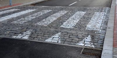
Lane Surfacing and Lane Textures
Lane surfacing and lane textures are an underused tool of lane delineation. Lane markings, paint colours, and different road surface materials can all be used to subtly change driver psychology. For example, cobblestone surfacing, even when used only in an alternating block style pattern, can reduce speeds by up to 10%. Checkerboard road surfacing, where painted road markings are used to cover the road with alternating black and white squares, has also seen promising trial results.
Lane surfacing and texture can also have a disproportionate impact on disabled people, cyclists, and people in wheelchairs or with mobility issues. Raised, painted road markings and similar interventions can present a challenge to cyclists when used to their maximum effect for calming traffic, and there is a delicate balancing act to be performed between encouraging sensible driving speeds and creating road surfaces which are accessible for all users.
One approach to lane texturing, raising, and surfacing is to work with cyclists, disabled people, and disabled communities, to ensure their feedback is taken on board and issues are resolved in a timely manner. It’s also important to consider the overall visual language, physical environment, and use pattern of the street as a whole before committing to a road surface which may be significantly different from those surrounding it.
Lane numbering and lane widths for cycles
Lane numbering is another useful tactical lane delineation tool. Lane numbers have been shown to reduce crash rates by up to 40% on residential streets and to have a self-calming effect. The use of lane numbers combined with lane width reduction to enforce one-way streets can also be very effective. Lane numbers can also be used to enforce cycle lane widths; a study in Essex found that reducing the cycle lane width and using lane numbers to police the enforcement actually improved cycling speeds, as the cyclists found themselves weaving between parked vehicles rather than following the painted line. Lane numbering can also be used in conjunction with other lane delineation techniques such as chicanes, pinch points, and bus lanes to enhance self-policing effects.
Lane narrowing and reallocating is, of course, not the only tactical solution. Croydon Council’s highly successful ‘living streets’ programme is an example of how high streets can be closed off to motorised vehicles by other means. Speed limits on motorways and A roads are a case in point for wider strategic and national transport interventions.
Dedicated Bus and Cycle Lanes: Priority and Politics
Perhaps the most politically charged tactical lane delineation interventions are those that create dedicated bus and cycle lanes by repurposing existing carriageway space. By their nature, these interventions prioritise sustainable transport modes over private motor vehicles, often reducing traffic capacity for general traffic in the process.
The evidence for the effectiveness of dedicated bus and cycle lanes in promoting sustainable transport modes and reducing traffic speeds and volumes is well-established. A study by Transport for London (TfL) of its cycle superhighway network—which combines painted lanes, segregated tracks, and signal priority—found that protected cycle lanes increased cycling volumes by an average of 46% within the first year of implementation, with collision rates per kilometre cycled decreasing by approximately 30% when cyclists were provided with dedicated, physically protected space.
Bus lanes provide similar gains in terms of public transport reliability and patronage. A 2020 report from the Urban Transport Group looked at bus lane schemes in seven British cities and found that journey time reliability improved by an average of 23% after implementation, with peak-hour journey times reduced by 12-18%. These improvements in reliability and speed were found to directly translate into increased bus ridership: average patronage on corridors where bus lanes were introduced increased by 8% on average in the same study, even as overall traffic volumes declined.
The challenge with bus and cycle lanes is not in the evidence for their effectiveness but rather in the politics of reallocating road space and managing the transition period, particularly in communicating the broader benefits to motorists who perceive themselves as losing road space. Bristol’s introduction of bus lanes along key radial routes in 2019 faced significant initial opposition, with local newspapers devoting considerable column inches to congestion issues in the first few months of implementation. However, 12-month post-implementation surveys revealed that 64% of residents, including 52% of regular car users, supported the changes, citing improvements in bus services, safer cycling conditions, and pedestrian environments.
The Cobblestone Conundrum: Heritage, Character, and Traffic Calming
Britain’s historic towns and villages are characterised by the widespread use of cobblestones and setts for street surfacing. While largely removed and replaced with smooth tarmac in the name of vehicular efficiency over the last century, the uneven surface of cobblestones provides an effective means of traffic calming. A number of conservation areas and heritage towns have begun reintroducing these historic materials in recent years.
In Ludlow, Shropshire, the market town centre retained its historic cobblestone surfacing in the face of pressure to resurface with modern tarmac. Comparing vehicle speeds on cobblestone sections with adjacent tarmac sections, traffic studies found average speeds on the cobbles were between 6-9 miles per hour slower, with a significantly reduced variance in speeds. The noisy and bumpy surface acts as a natural deterrent to speeding, creating visual, auditory, and tactile feedback to drivers.
In York’s Shambles, one of Britain’s best-preserved medieval streets, cobblestones are also being used as part of a traffic management strategy. When the street was pedestrianised in 2014, the historic setts were restored and extended across the whole length, with vehicle access restricted to the early morning for deliveries. The cobbled surface serves a dual purpose here: it marks out the shared space and communicates the historic nature of the street, while ensuring that limited vehicle access occurs at slow speeds.
Accessibility is an obvious downside of the uneven surface, which can be difficult or impossible to negotiate in wheelchairs or with pushchairs. Historic England guidance on using cobblestone setts in contemporary road schemes recommends creating smooth and level routes through cobbled sections using carefully selected and laid setts or flush stone strips. Stamford in Lincolnshire has pioneered a solution to this issue, with its town centre improvement scheme retaining historic cobblestones across much of the market square but incorporating flush granite strips in key pedestrian desire lines. These provide level routes for wheelchair users and prams, and parents with young children, while retaining the historic character of the town and the traffic-calming benefits of a cobbled surface.
Dr James Hartley, a conservation architect specialising in historic towns, says there are wider lessons for traffic calming in cobblestones. “The thing about cobbles is that they work on a number of sensory levels: they’re something you can see, something you can hear, and something that the driver actually feels through the vibrations they produce. Modern traffic calming tends to focus on visual cues, and those are very easy to ignore. The noise and vibration of cobbles provides unavoidable feedback, and we should be thinking about how to build that into other materials and surfaces.”
Tactical lane delineation faces a number of implementation challenges despite its compelling evidence base. At the institutional level, the traditional highway engineering paradigm that prioritises vehicle capacity and speed remains deeply embedded in many local authority transport departments, with significant inertia against shifting towards a more human-centric approach. That institutional culture is then reinforced at the political level, where elected officials are often risk-averse and defensive in the face of vocal community opposition to reallocation of road space or traffic calming measures that reduce vehicular speeds or capacity.
Community engagement is critical to the success of tactical lane delineation projects. London Borough of Waltham Forest’s “Mini Holland” programme—arguably the most ambitious and transformative street space reallocation initiative in Britain to date—invested significantly in community consultation and iterative design to build support. The council engaged with residents extensively throughout the process, organising workshops, open houses, and feedback sessions at every stage, from initial concept to post-implementation review.
Opposition was vocal, with minority interest groups mobilising both locally and online to protest the changes. However, the council’s willingness to adapt designs in response to legitimate concerns and its commitment to evidence-based decision-making helped to build wider community support. Three years after implementation, independent surveys showed that support for the changes had increased to 61% of residents, up from 42% before the works began. Cycling had increased by 93%, walking by 12%, and bus ridership by 8%, even as vehicle traffic declined by 16%.
What was particularly telling about the Waltham Forest case is that property values in the intervention areas increased by an average of 4% more than in comparable areas without the street improvements, suggesting that the market recognised and valued the improved urban environment.
The Waltham Forest example underscores the importance of framing lane reallocation and traffic calming not as anti-car measures but as pro-people interventions that create better streets for all users. This messaging, focusing on the benefits—safer streets for children, improved air quality, better local business environment, more reliable public transport—can help to build community support and mitigate opposition.
Conclusion: Tactical Lane Delineation as a Tool for Reclaiming Streets
Tactical lane delineation is more than just a set of technical interventions for traffic management. It is a paradigm shift in the way we think about and design our streets. Rather than seeing road markings and surface treatments as a technical detail or background setting, tactical lane delineation recognises them as powerful tools for shaping behaviour, redistributing space, and reclaiming our streets for people rather than vehicles.
The evidence for the effectiveness of these tools in creating safer, more sustainable, and liveable streets is compelling. Lane narrowing slows traffic without compromising safety. Chicanes and pinch points create self-enforcing traffic calming. Pedestrian refuge islands enhance both safety and accessibility. Dedicated bus and cycle lanes improve public transport and sustainable travel, reducing overall traffic volumes. And even traditional materials like cobblestones can be repurposed as a traffic calming measure that adds heritage value when thoughtfully applied.
These interventions are not without challenges, of course. They require political will, community engagement, and a willingness to disrupt the status quo of decades of car-centric urban planning. But they are also proven, cost-effective, and rapidly deployable tools for street transformation that can help us to meet the challenges of air quality, public health, climate change, and urban liveability that British cities and towns are all facing.
As we design the streets of the future, we have an opportunity and a responsibility to create places that prioritise people over vehicles, community over speed, and quality of life over traffic capacity. Tactical lane delineation gives us the tools to do that.